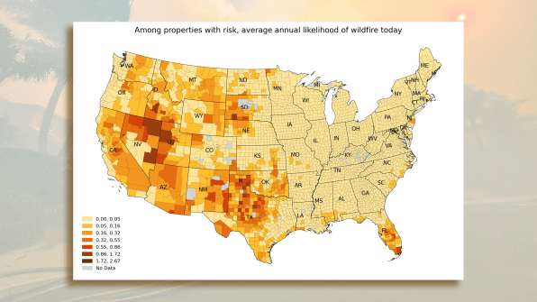
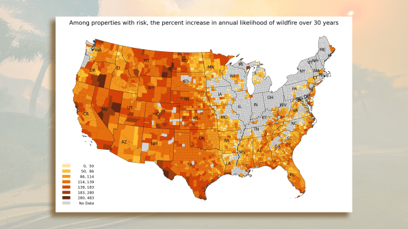
These maps show how wildfires are changing in the U.S.—and the risk at your address
Over the last two decades, the area burned by wildfires in the Western U.S. has quadrupled; in the Great Plains, it’s grown by seven times. The number of individual wildfires has also increased in almost every part of the country, and as climate change progresses, fires will get worse. A new tool helps show how much risk your house or apartment—or a house you might want to buy—faces from wildfires.
“Up until this point, there’s been nothing from the government or from private industry that looks at a building’s specific risk of wildfire today, how your home may be impacted, and then how that’ll change over the next 30 years from climate change,” says Matthew Eby, founder and executive director of First Street Foundation, the nonprofit that released the new tool, called Fire Factor.

The team developed a peer-reviewed model that considers multiple factors, from topography to the presence of burnable fuels like trees, and then repeatedly ran it under a wide range of weather conditions. “We need to run that model 100 million times, across all its components, in order to build up a probabilistic map of how wildfire can move across the landscape,” says Ed Kerns, chief data officer at First Street Foundation. For each property, the model considers the specific building materials and the age, since older homes may be less likely to have features like vents that prevent burning embers from being sucked into an attic.

A tool the nonprofit built earlier, called Flood Factor, calculates the risk of flooding at specific homes. Now, both the flood and fire tools will be available on a site called Risk Factor. The same data will also be available on Realtor.com, where prospective buyers can quickly understand the risks for any property.
The risks aren’t limited to states like California or Colorado; fires are also increasing in a large part of the country, including Southeastern states like the Carolinas, Kentucky, and Tennessee. “There’s a lot of fuel there—a lot of forest, a lot of vegetation,” says Kerns. “And it’s going to become drier and drier and warmer and warmer within with the changing climate. Those fuels will dry out and become more combustible.” That can happen quickly even in humid, wet states like Florida, which already frequently experiences major fires.
When homeowners better understand their risk, they can take steps to protect their homes, such as clearing vegetation to create a buffer zone around the house or swapping a wooden roof for metal. Governments can also use the model to look at larger maps and strategize about where to add bigger infrastructure like fire breaks, or to decide which communities face the most risk and need to be first in line to get funding to become more resilient.
As people look at their fire or flood risk, Eby recommends looking beyond their own address. “The home is only as safe as the community it’s a part of,” he says. “Unfortunately, some homes are totally safe, and they see the fire factor or the flood factor for their individual property and think it’s okay, but you need to kind of scroll a little to see what’s going on in the community—what roads are at risk, what critical infrastructure is at risk, what social infrastructure like schools and government buildings are at risk–so that you understand kind of the full picture.”
Fast Company , Read Full Story
(28)


