An El Niño winter is on the horizon. Here’s what’s in store for the U.S.
It looks like an unusual winter is on the horizon. For the first time in seven years, the National Oceanic and Atmospheric Administration (NOAA) has predicted a “strong” El Niño event in the coming months. While meteorologists first issued an El Niño advisory in June, a recent report sheds more light on how the climate pattern is expected to develop. Here’s everything you need to know about the weather phenomenon.
What is El Niño, anyway?
El Niño and its foil, La Niña, are opposite ends of a weather cycle known as the El Niño/Southern Oscillation (ENSO). El Niño events tend to take place every two to seven years and reach their peak intensities between December and April, although every occurrence has unique characteristics and intensities.
During the El Niño phase, warmer than normal sea surface temperatures develop across the central and eastern equatorial Pacific Ocean. The change kickstarts what scientists call a “feedback loop” with the atmosphere: As eastern sea surface temperatures rise, trade winds weaken, setting off a chain of events that cause temperatures to rise even more. In the U.S., El Niño winters typically lead to markedly different weather conditions in the North compared to the South. The same can be said during La Niña events, which represent the cold phase of the ENSO cycle.

What will the upcoming El Niño winter look like in the U.S.?
We’ve seen El Niño winters before—most recently in 2018/19, NOAA Meteorologist Nathaniel Johnson says in an email to Fast Company. That was a weak El Niño, though. The last strong El Niño, which was one of the strongest in known history, was in 2015/16. It continues to hold the record as the warmest winter for the U.S. mainland. Extreme storms accompanied the altered climate, and in January 2016, a deadly blizzard buried the East Coast in dozens of inches of snow.
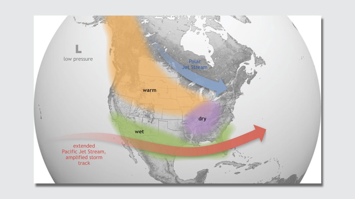
While experts can’t predict the impacts of the upcoming El Niño winter, several weather patterns are most likely to emerge. “El Niño typically brings cool and wet winter conditions to the Southern U.S., from Southern California through the Southeast,” Johnson says. “Drier-than-average conditions are typical for the Pacific Northwest and Ohio Valley region. The Northern tier of the U.S. tends to be warmer than average.”
Per NOAA’s most recent ENSO Outlook, these conditions are expected to last until around January to March 2024, and there is now a 71% chance that the event peaks as a strong El Niño winter. This classification signifies that the chance for certain extremes goes up.
“That would mean an increased probability of atmospheric rivers and extreme rain and mountain snow throughout the entire Southern tier of the country,” Johnson says. “Dry extremes are more likely in the Northwest around Montana and Wyoming and in the Ohio Valley. Cold extremes are more likely in the Southern U.S. from about New Mexico extending eastward through the entire Southeast, especially in late winter and early spring. Warm extremes are more likely to the North, particularly in the Northern Plains.”
However, increased risk doesn’t necessarily mean that local impacts are inevitable. Experts can’t be sure yet how this El Niño will compare to those in previous years.
How might this year be different from previous years, and what role does climate change play?
By their very nature, El Niño winters are variable. But the circumstances surrounding this year’s event are already unusual. In July, the global average sea surface temperature hit an all-time record high of 69.73 degrees Fahrenheit. For meteorologists, this meant that El Niño’s warmer-than-average temperatures in the Pacific Ocean didn’t stand out nearly as much as usual compared to the Atlantic, Indian, Arctic, and Southern Oceans. In short, all of the ocean basins were hot. This winter, El Niño’s influence on the climate will be superimposed over an alarmingly warm globe.
As for the direct impact of climate change on El Niño, scientists are actively investigating that connection. “Some recent research suggests that global warming may make El Niño and La Niña events stronger and more frequent,” Johnson says. And even if El Niño and La Niña events themselves don’t change, he notes, the way that the weather interacts with tropical Pacific conditions could. “For example,” he adds, “some studies indicate that the atmospheric circulation response to El Niño in the North Pacific will strengthen and shift eastward under global warming, which would alter the impacts over the U.S.”
(31)


