Fall Foliage Map 2024: Best dates to enjoy the season’s changing colors in your area
Fall Foliage Map 2024: Best dates to enjoy the season’s changing colors in your area
Nature’s most colorful show is about to begin.
On September 1, meteorological fall officially began, and in less than three weeks, on September 22, astronomical fall will, too (aka, what we generally call the autumnal equinox). That means the season has begun when the leaves start changing from green into beautiful yellows, oranges, reds, and gold.
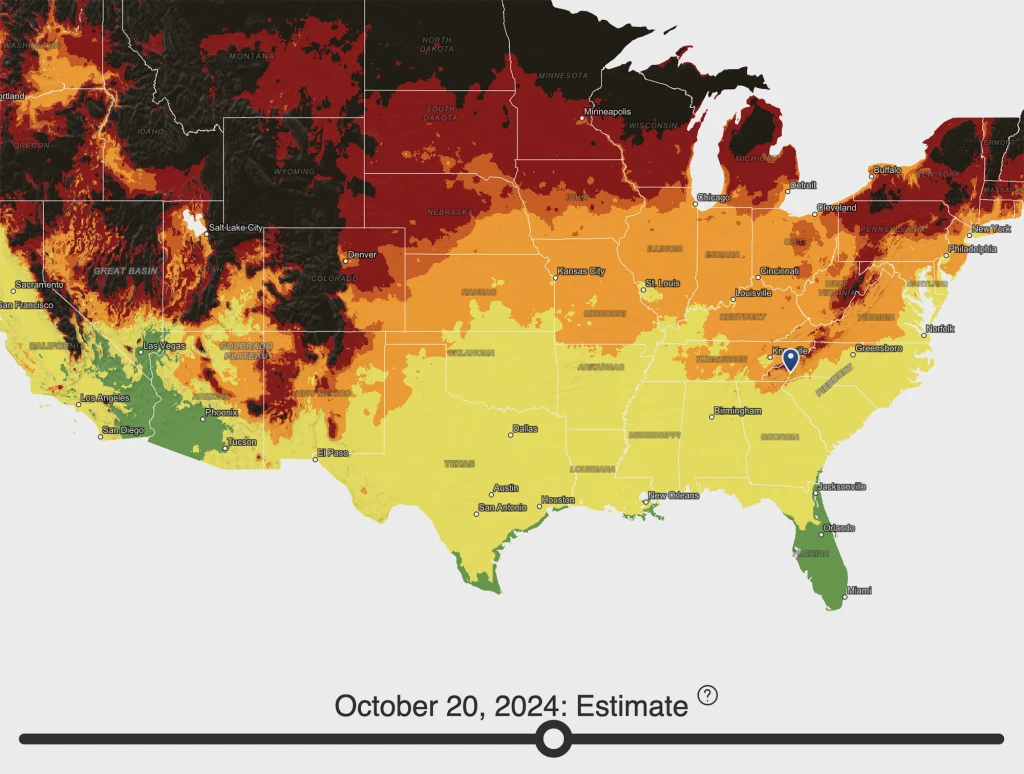
And depending on where you are in the country determines when you can expect to see fall foliage. Two primary factors control the timing: daylight and temperature. So the further north and the higher in elevation a tree is, the earlier it will reveal its true colors. If you don’t want to miss peak viewing season in your area, there is a helpful interactive map that shows when fall leaves will be at their prime.
The map is from Explore Fall, a website dedicated to fall foliage. A slider below the map allows you to watch how the colors are changing across the country. As the colors progress southward, they will change from green (no to little fall colors) to yellow (low colors), to light orange (moderate colors), to dark orange (high colors), to maroon (peak colors), to black (post-peak colors).
Another excellent feature of the map: You can enter your location, which the map zooms in on, so you can see when peak viewing season is estimated to occur in your area.

According to Explore Fall’s map:
- Peak color season for the northernmost states will occur somewhere between October 7 to October 20.
- Peak color season for the central band of states will occur sometime between October 20 to November 5.
- Peak color season for southern states will occur sometime between November 10 to November 30.
Of course, these are peak viewing times, and some zones will overlap. Low to moderate colors can begin as early as September 20 in the northernmost part of the country and work their way south throughout October and November. And according to the Explore Fall website, estimates are accurate within three days 80% of the time. The map is updated daily at midnight, addressing and correcting any inaccurate information. And for true diehards, Explore Fall provides a weekly blog so you can keep up with the latest fall color progressions.
The fall foliage map from Explore Fall is powered by data from the Environmental Protection Agency (EPA), the Environmental Systems Research Institute (Esri), the Food and Agriculture Organization of the United Nations (FAO), Garmin, the National Oceanic and Atmospheric Administration (NOAA), TomTom, the U.S. Fish and Wildlife Service (USFWS), and the United States Geological Survey (USGS). So, they’re not fooling around.
ABOUT THE AUTHOR
Fast Company
(5)


