Hitting the Books: Uncovering ancient civilizations with a plane and a prayer

The early days of archaeology involved immense amounts of backbreaking work just to find sites at which to dig. In the time before GPS and satellite imagery, locating the ruins of ancient towns and villages was akin to finding a needle in a haystack hidden in a jungle on the side of a remote mountain. But Gordon Willey was no dummy. As the excerpt from Maps for Time Travellers by Mark McCoy shows, instead of traipsing through the Peruvian backcountry in hopes of stumbling across an archaeological site, he had the bright idea of using aerial photos acquired from the Peruvian Air Force to search for potential digs — all without leaving the relative comforts of Lima. His ingenuity helped revolutionize, and modernize, humanity’s search for its long-lost civilizations.

From Maps for Time Travelers: How Archaeologists Use Technology to Bring Us Closer to the Past by Mark D. McCoy. Copyright © 2020 by Mark D. McCoy. Reprinted with permission from University of California Press.
Gordon Willey grew up during the Great Depression in a middle-class household, and excelled in his studies in high school and college. But, in 1936, all his applications to graduate schools were rejected. Undeterred, he joined digs around the country and a few years later was admitted to Columbia University. Archaeology at this time was all about chronology: digging places rich in artifacts and using their changing styles to build up a culture history. And Willey did just that for his dissertation research in Peru, which he completed shortly before America entered World War II.
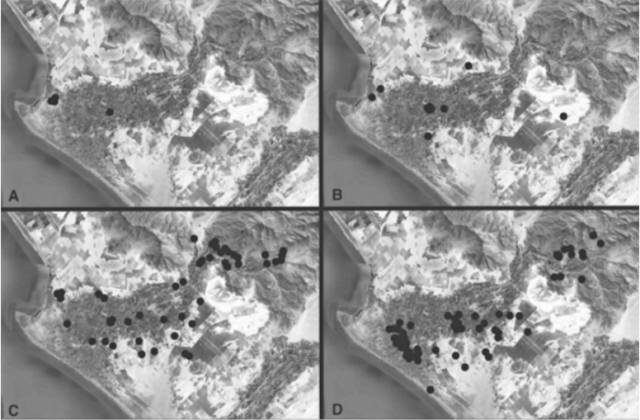
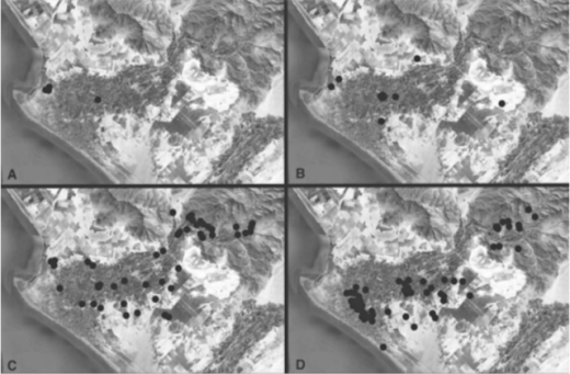
Next, Willey took a big, big risk. After the war he returned to Peru as part of a Smithsonian research team to undertake something that no one had done before. The target was Viru Valley, a place with a climate not unlike Southern California. The idea was to look for the foundations of ruins representing settlement across an entire coastal valley and reconstruct the pattern of where people lived in different periods (see figure 6).

Mapping during the 1946 survey required walking over what Willey later called, the “stony and seemingly endless remains of Viru’s prehistoric settlements” (1974, 154). He was accustomed to fieldwork in Peru so that didn’t worry him. His real worry was that by spending nearly the whole time hiking around instead of digging up some deposit rich with artifacts, he was wasting his time, and to some degree putting his future professional career in question.
The success of the survey was thanks in large part to contributions by James A. Ford. Jim Ford, a self-described overgrown country boy from Mississippi, was just a couple of years older than Willey and today is best known for his work with artifacts in North America. It was Ford who had the idea that they could use air photos to map the valley efficiently. At the start of the season, before heading to Viru, the team stopped off in Lima. There they bought twenty-two air photos, each about half the size of a movie poster.
The survey had been flown by the Peruvian Air Force and printed at a 1:10,000 scale. It is hard to see anything at that scale.Two football fields set end-to-end would be just two centimeters long so things like the foundations of houses were too small to see.
To make the photos useful, they used a type of projector that let them blow up each picture and then make maps at a 1:700 scale by tracing the projected image. At that scale two football fields would be more like thirty centimeters. Viru Valley’s ancient architectural features — walls, mounds, and pyramids made of earth and stone — stood out from the surrounding natural landscape on air photos because, for lack of a better description, they looked like weird shadows. Having traced the shadows to create maps revealing the locations of architecture, the crew not only had a good idea how to navigate but also an idea of what was there before they arrived.
Viru Valley has its share of big stunning architecture. But Willey and the Smithsonian team wanted to locate and map all kinds of different places, including places where people lived, farmed, and worshipped. After four months of chasing down weird shadows on air photos the team came back with results that exceeded expectations. They had recorded archaeology in three hundred locations.
That is a lot, but the number was not as important as the picture that emerged when they put them in order of construction. In those days, the order was based on the artistic styles and types of artifacts observed on the ground surface, especially pottery.
Broadly speaking, they found the earliest farmers who settled in the valley had built “no mounds or special buildings” (Willey 1953, 400). As time passed, villages marked by small houses emerged, with buildings that might have been temples or had some other use to the community. Later, the first pyramids, fortifications, and palaces were built. Importantly, Willey and his team also traced the history of a massive investment in canals to irrigate fields. Mundane, sure. But with the canals the natural environment of the valley allowed for the production of enough food to support a large and growing population. The distant past was starting to make sense, remarkably, without a massive amount of digging.
A few years after the Viru Valley project, Willey was given an endowed chair at Harvard—one of the universities that had rejected him in his first attempt at graduate school—and he introduced the world to his new way of looking at archaeology like this:
The material remains of past civilizations are like shells beached by the retreating sea. The functioning organisms and the milieu in which they lived have vanished, leaving the dead and empty forms behind. An understanding of structure and function of ancient societies must be based upon these static molds which bear only the imprint of life.Of all those aspects [of prehistory]. . . which are available to the archaeologist, perhaps the most profitable for such an understanding are settlement patterns. (Willey 1953, 1)
In other words, by studying settlement patterns archaeologists could potentially see the real-world consequences of all sorts of things, such as how populations grew and societies evolved.
Interest in settlement patterns caused a boom in the use of air photos in archaeology. All around the world in the 1960s and 1970s, a whole generation of archaeologists went forth into the backcountry—no GPS, no cell phones, just marked-up air photos in their backpacks, and what they hoped was a reliable Jeep. We had finally come to appreciate that to ask and answer interesting questions it would be necessary to be able to say what was going on around a single location, or between locations, rather than limit our focus to excavations in one place. That idea—that you could read the past from looking at changes in the arrangement and types of settlements—was itself revolutionary.
(23)


